Summary overview of the changes coming in our latest release
Hello and welcome to our video which will give you an overview on the updates being to eSpatial in our latest release to enhance your user experience using our territory manager.
Updates to Datasets used for Territories:
New ZIP code Dataset:
We now have a new ZIP code dataset available for use. This new dataset will be of higher quality and will be more regularly updated than our existing ZIP Code Tabulation Areas (ZCTA) dataset. It will be available to use in your maps and territories allowing for a more current analysis of your data.
Also don't worry if you prefer to use the ZCTA's our existing ZCTA dataset will still be available to use in your maps.
US Counties:
We have also updated our US counties dataset in Territories to include FIPS codes as US counties names are not unique identifiers across the US.
This also means that you will need to have a FIPS code column in your territory dataset if you wish to create territories from File using US counties, as the FIPS code will now be used to link your dataset with our US counties Boundary Layer
Detailed control and Management of Territory Changes:
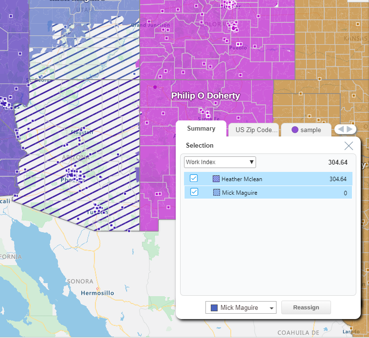
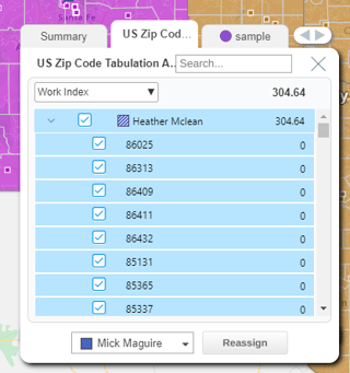
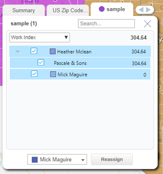
We have improved the way you assign boundaries such as zip codes and counties. Our new selection and assignment tool allows you to bulk add boundaries to areas and see a summary of the changes, as well as a detailed outline of the boundaries being moved i.e. ZIP codes, counties etc, the balance change and the accounts that are being allocated or reallocated to your selected territory.
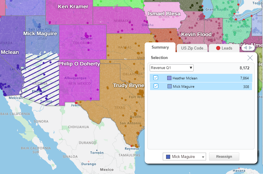
The selection and assignment panel also gives you the option to select and deselect which areas are transferred to your selected territories as well as accounts or leads if you have added balances.
Reassigning Areas:
+ Icons
As before you can assign or reassign boundaries to your territories using the + icons when you hover over the desired boundary.
Now when you click on the plus icon the selection and assignment panel will appear giving you a summary of the changes you are making and the boundaries and accounts within the area you have selected.
Select which territory you wish to assign these boundaries to from the drop-down menu and select reassign.
Select Areas Tool
To assign and reassign boundaries using the select areas tool, select the select areas icon in the territory panel and begin clicking to draw your area. Then either double click or select the tick icon to confirm the area.
Like reassigning using the + icons, the selection panel will appear where you can see a summary of the changes you are making and the boundaries and accounts within the area you have selected.
Finally, select which territory you wish to assign these boundaries to from the drop-down menu and select reassign.
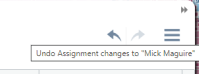
Undo and Redo:
We are pleased to announce that the frequently requested functionality of Undo and redo is available when creating your territory alignments. You can now undo up to three of your last made territory changes such as adding and removing areas from territories.
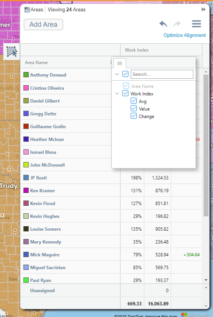
Configurable Territory Panel:
Another highly requested feature that we have implemented as part of our new release in a configurable Territory Panel.
- This allows you to choose which balances to display in your territory panel and whether they are displayed as your average percentage, the exact count value in the territory or the count change compared to the last saved point.
- You are able to sort your territories based on your highest/lowest values and you can also move and hide columns so that you can view the most important to you.
New Optimizer Features:
Users that have purchased our territory optimization feature can now avail of the following changes:
New Datasets:
We have expanded the datasets which can be used to create optimized territories, previously users were limited to US Zip Code Tabulation Areas and US counties.
We have expanded our selection to include the new Zip Code 2021 dataset as well as new datasets of UK Postcode Sectors, Districts and Areas and Canadian Forward Sortation Areas (FSA’s) and Canadian Census Divisions.
Hierarchies:
It is now also possible to create optimized territories on up to 3 levels of territory hierarchies.
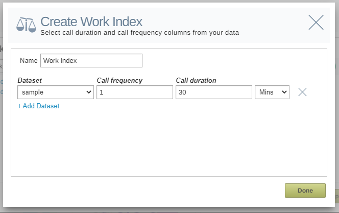
Work Index:
We have created a new balance option called work index. This can be combined with other balances to create the best territory alignment model that works best for your business.
This metric reflects the amount of effort required to service each territory, and is calculated based on call frequency, call duration and travel time. With this balance you can set the call duration and frequency, while eSpatial provides the travel time.
Advanced Territory Features:
Previously only users that had purchased Optimized Territories had access to our Fill Gaps feature. We are pleased to announce that this is now available for users that have purchased our advanced territory features.
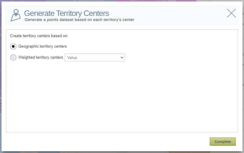
Territory Centers:
A new feature available to Users with our advanced territory features is the ability to generate territory centers. This allows you to generate a point dataset that calculates the center point of your territory based on either the geographical center of your territories or weighted centers based on your balance data.
Finish:
Thank you for watching our video on our latest eSpatial release. If you have any further questions, you can reach out to us by emailing help@eSpatial.com or by contacting us through our chat to the left-hand side of your screen when on our website or logged into eSpatial.