Information about the import API method.
NOTE: This is an Enterprise Feature, it is only available for users who have purchased our Complete Solution Plan.
editFeature
Purpose
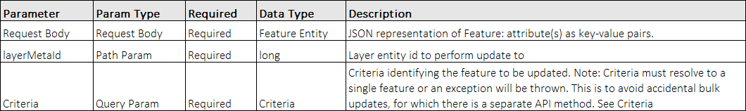
Edit a feature in a dataset by passing key-val pairs for attributes and a layerMetaId. If one of the address fields is modified a re-geocode will take place on the server and cause the feature to be moved on the map.
Request URL
PUT https://maps.espatial.com/esWebAPI/rest/v1b/import/{layer_meta_id}/feature
PUT https://maps.espatial.com/esWebAPI/rest/v1b/import/{layer_meta_id}/feature?criteria={"$type":"Equal","attr":"COMPANY","value":"Mills Insurance"}
Request Parameters
Response
[{
   "$type": "DefaultLayerMeta",
   "created": 1433511718531,
   "defaultStyler": {
      "$type": "SingleStyler",
      "style": {
         "$type": "SymbolStyle",
         "color": 4292686388,
         "size": 30,
         "symbolTypeId": 8
		       }
   },
   "description": "sample",
   "featureSourceId": 5062,
   "geoLocationMeta": {
      "$type": "AddressGeoLocationMeta",
      "attrNames": [
         "ADDRESS",
         "CITY",
         "COUNTY",
         "STATE",
         "ZIP"
		 ],
      "countryCode": "US",
      "region": "United States"
   },
   "geomExportable": false,
   "geomType": "POINT",
   "id": 4062,
   "labelAttr": "COMPANY",
   "lastModified": 1433511718531,
   "maxResolution": 0,
   "minResolution": 0,
   "sourceTenantId": 224310,
   "title": "sample"
}]
createFeature
Purpose
Create a feature in a dataset by passing key-val pairs for attributes and a layerMetaId.
Request URL
POST https://maps.espatial.com/esWebAPI/rest/v1b/import/{layer_meta_id}/feature
Request Parameters

Response
[
   {
      "$type": "DefaultLayerMeta",
      "created": 1433511718531,
      "defaultStyler": {
         "$type": "SingleStyler",
         "style": {
            "$type": "SymbolStyle",
            "color": 4292686388,
            "size": 30,
            "symbolTypeId": 8
            }
		},
		"description": "sample",
		"featureSourceId": 5062,
		"geoLocationMeta": {
		   "$type": "AddressGeoLocationMeta",
		   "attrNames": [
		      "ADDRESS",
		      "CITY",
		      "COUNTY",
		      "STATE",
		      "ZIP"
         ],
         "countryCode": "US",
         "region": "United States"
	},
	"geomExportable": false,
	"geomType": "POINT",
	"id": 4062,
	"labelAttr": "COMPANY",
	"lastModified": 1433511718531,
	"maxResolution": 0,
	"minResolution": 0,
	"sourceTenantId": 224310,
	"title":
	"sample"
}]
importURL
Purpose
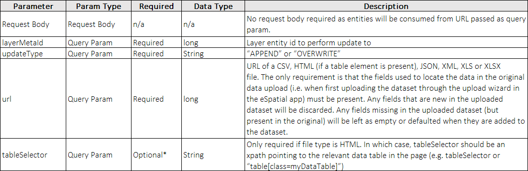
Perform a bulk update of a dataset by passing the URL of a file.
Request URL
POST https://maps.espatial.com/esWebAPI/rest/v1b/import/url
POST https://maps.espatial.com/esWebAPI/rest/v1b/import/url?url=https://www.espatial.com/sample/sample-short-modified.csv&layerMetaId=108179&overwrite=true
Request Parameters
Response
Response body is the number of records/features in the URL that have been counted for processing. Response code is 202/Accepted as the geocoding process can be time consuming.
10
A response header “Column-Match-Summary” is also returned which will give an indication of which fields passed up were processed.
importFile
Purpose
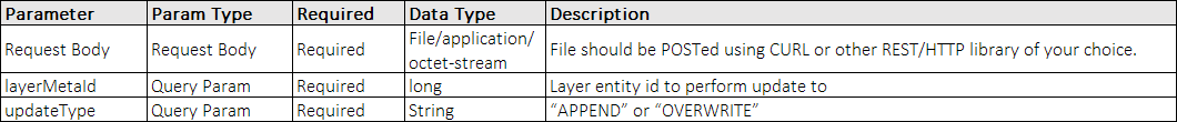
Perform a bulk update of a dataset by POSTing a file.
Request URL
POST https://maps.espatial.com/esWebAPI/rest/v1b/import
Request Parameters
Response
Response body is the number of records/features in the URL that have been counted for processing. Response code is 202/Accepted as the geocoding process can be time consuming.
10
A response header “Column-Match-Summary” is also returned which will give an indication of which fields passed up were processed.
Code Samples
Below are two code samples posting a multipart file to eSpatial for import.
Using C# with RestEasy lib:
static void doMultiPartPostToESpatial()
{
   var client = new RestClient("https://maps.espatial.com/esWebAPI/rest/v1b");
   client.Authenticator = new HttpBasicAuthenticator("kflood@espatial.com", "***");

   var request = new RestRequest("import?layerMetaId=179995&updateType=OVERWRITE", Method.POST);
   request.AddHeader("Content-Type", "multipart/form-data");

   request.AddFile("file", "c:/inbox/sample.csv", "application/octet-stream");

   // easy async support
   client.ExecuteAsync(request, response => {
      Console.WriteLine(response.Content);
   });
}
Using Java with Jersey lib:
private Response doMultiPartPostToESpatial(){
   String url = "https://maps.espatial.com/esWebAPI/rest/v1b/import";

   final ClientConfig clientConfig = new ClientConfig();
   HttpAuthenticationFeature feature = HttpAuthenticationFeature.basic(auth.getEmail(), auth.getPassword());
   clientConfig.register(feature);
   client = ClientBuilder.newClient(clientConfig);
   client.register(MultiPartFeature.class);


   // MediaType of the body part will be derived from the file.
   FileDataBodyPart filePart = new FileDataBodyPart("file",
      new File(filepath),
	  MediaType.APPLICATION_OCTET_STREAM_TYPE);

   FormDataMultiPart multipart = (FormDataMultiPart)new FormDataMultiPart().bodyPart(filePart);

   Response res = client.target(url)
      .queryParam("layerMetaId", layerMetaId)
	  .queryParam("updateType", "overwrite")
	  .request(MediaType.APPLICATION_JSON_TYPE)
	  .post(Entity.entity(multipart, multipart.getMediaType()));
   return res;
}